Hundreds of metres below the surface off Newfoundland and Labrador, baited underwater cameras record life on the seafloor.
The footage gives Fisheries and Oceans Canada researchers a direct view of species living where observation is otherwise difficult and expensive, and a way to test whether offshore activities, including seismic surveys, are affecting marine populations.
Collecting the footage is only the beginning. A single survey produces around 10 terabytes of video. To turn those recordings into evidence, scientists identify, count, and sometimes measure every animal that appears, traditionally by hand.
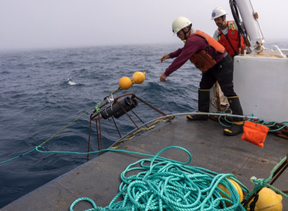
Image courtesy of Fisheries and Oceans Canada (DFO). All rights reserved.
Through a multi-year research collaboration with DFO, Deep Oculus co-founder and Chief Scientist Devi Ayyagari developed a machine-assisted approach for analyzing this footage at scale, keeping scientists in the process throughout.
The Challenge
Before any analysis can begin, each survey's footage has to be ingested, quality-screened, and organized into a form scientists can work through. That preparation is substantial work in itself.
Once the footage is ready, the annotation begins. Every survey brings different species, habitats, and image conditions, so a model trained on earlier footage cannot be relied on until experts have annotated a fresh round of examples. That annotation burden is one of the biggest barriers to scaling underwater video analysis across surveys, locations, and years.
The Solution
The project introduced a human-in-the-loop workflow in which AI makes the first pass, detecting and classifying animals across the full video set.
Scientists then review the suggested annotations, correcting, removing, or adding detections as needed. Each detection carries a confidence signal, so reviewers can see where the model was certain and where it was hesitant. Animals that match nothing the model has seen before are flagged for closer expert review.
Those corrections are used to improve the model for future surveys, creating an adaptive process that becomes more useful over time.
Every detection also carries a record of its origin: machine-proposed, expert-confirmed, or expert-added. Any count can be traced back to the frame it came from.
The Results
The workflow ran across three years of seismic surveys, producing counts of multiple groundfish species. Scientists worked faster by reviewing suggested annotations instead of starting from scratch, and across changing survey conditions the system produced results consistent with manual assessment while keeping every detection traceable and expert-reviewed.
This gave DFO scientists the evidence base to assess how offshore oil and gas surveys may affect groundfish populations, across volumes of video that manual annotation alone could not have covered.
"Machine-assisted annotation allowed us to review hundreds of underwater videos that would have been impractical to analyze by hand."
— Corey Morris, Biologist, Fisheries and Oceans Canada
Published Research
The methods behind this work are documented in three peer-reviewed publications.
- Dataset Selection Is Critical for Effective Pre-training of Fish Detection Models for Underwater Video. ICES Journal of Marine Science, 2025
- Detecting Unexpected Marine Species with Underwater Cameras and Deep Learning. OCEANS 2024 Halifax
- Toward Low-Cost Automated Monitoring of Life Below Water with Deep Learning. Environmental Data Science, 2023
Turn Your Underwater Footage into Actionable Evidence
Deep Oculus builds AI infrastructure for organizations collecting underwater video and sensor data.
Whether you are monitoring marine populations, assessing environmental effects, or producing counts that need to hold up under review, we can help turn large volumes of difficult footage into reviewable, traceable results.
Talk to us about your underwater monitoring project.
Images were captured by personnel at Fisheries and Oceans Canada (DFO) and are reproduced here with permission. The images belong to Fisheries and Oceans Canada and may not be copied, reproduced, modified, published, distributed, or otherwise reused without prior written permission from DFO. All rights reserved.
Funding for the fieldwork and camera development was provided by the Environmental Studies Research Fund (ESRF) through Project 2018-01S.